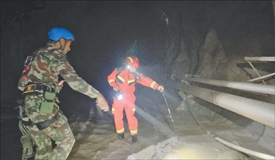
Earlier, Chinese tunnel rescue experts (right) conducted search and rescue work with Nepalese workers in the disaster area in Nepal.
China Tunnel Rescue Expert Team Offers Pictures
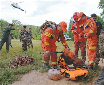
On August 31, at the Nepali Front Rescue Command Center in Nuwakode County, Nepal, Chinese tunnel rescue experts returned after completing a search mission.
Establishing a WeChat working group with the Nepalese weather department to share relevant information in real time; developing a Chinese-Nepalese border weather joint venture; developing a customized version of “Mazu” specifically for the Nepalese Hydrological Weather Bureau…
After the “8.26” mudslide disaster in Nepal, our weather, water, natural resources, and other departments developed close cooperation with Nepal‘s relevant departments, sharing monitoring information, providing weather, hydrology, and other products and services, and jointly responding to the disaster.
Forming Special Class for Meteorological Protection in Nepal to Share Meteorological and Hydrological Monitoring Information
On the morning of August 26, a landslide disaster occurred on the Nepal side, causing severe damage to the Khirong port in Khirong County, Jikaze City, Xizang.
The Jilong Pass is located in the Tibetan Plateau region, which is high above sea level, with complex terrain conditions and variable weather. “This year, from late August to early September, the Plateau, especially along the border line, has active cold air and more rainfall weather, which poses a severe challenge to rescue work,” said Ma Xuejun, chief forecaster of the National Meteorological Centre.
“At noon on August 26, we received the relevant requests from the Nepalese Hydro-Meteorological Administration. We organized the first joint talks early that afternoon, and the second joint talks with the Nepalese were held on the afternoon of August 31,” Zhang Tianhang, a senior engineer at the China Meteorological Administration‘s World Meteorological Center (Beijing) operating office, told reporters. Previously, the two sides had established a WeChat working group to share relevant information in real time.
On the afternoon of the 26th, the emergency joint venture relied on Mother‘s cloud-based weather early warning business platform to jointly conduct a weather situation study to analyze the subsequent rainfall development situation.
Subsequently, the China Meteorological Administration established the Nepalese Meteorological Protection Task Force, which provides the Nepalese with an English-language special report on the weather monitoring and forecasting service every day. The special report is very detailed, including the monitoring situation and future forecasts.
The monitoring reality section provides infrared cloud maps from wind and cloud weather satellites, as well as a 1-kilometer resolution temperature and precipitation reality product around the disaster area. In addition, at the request of Nepal, the latest issue also provides lightning monitoring products based on wind and cloud weather satellites.
On the forecasting side, we mainly provide weather forecasting products with 1-kilometer resolution for the next 7 days near the disaster area, while also providing rainfall forecasting products for the next 3 days and the next 7 days. “In addition to this, we also continuously update extended-period forecasts for 15-30 days. Overall, we provide seamless forecasting services for Nepal within 30 days, providing strong support for Nepal‘s rescue efforts,” Zhang Tianhang said.
After the disaster, a dammed lake formed near the junction of the Chokian River in Nepal, which flows into the Nepjep-Chang-Zambu in our country.
The Ministry of Water Resources immediately dispatched a hydrological emergency monitoring team to assist in the first line of action. Together with staff from the Xizang Autonomous Region’s Hydrological Water Resources Survey Bureau, they launched a hydrological monitoring and forecasting early warning.
Currently, the Ministry of Hydraulics provides the Nigerian side daily with 5 aspects of information, including the development situation of the Puget-Changjiang Tibetan reservoir lake, the chain-risk study of the impact crater on the Chokjian River, the risk screening situation of the ice lake in the Kuala Lumpur Tibetan basin, the development and risk prediction of new reservoir lakes, and hydrological emergency monitoring information, providing strong support for rescue efforts downstream in the Nigerian territory.
Providing a customized version of the “Mamzu” meteorological intelligence warning plan to Nepal to make up for insufficient monitoring
Only 17 weather observation sites across Nepal are shared with international organizations, and the coverage density is insufficient.
China has built the world‘s largest space-space integrated comprehensive three-dimensional weather observation system, with high-end observation equipment such as wind-cloud weather satellites and weather radar performing superior performance.
After the disaster occurred, the China Meteorological Administration immediately deployed relevant deployments, mobilizing state, provincial, municipal, and county-level forces to establish emergency protection special teams. On the night of the 26th, small ground observation stations were deployed to the vicinity of the disaster area, and a mobile weather radar was deployed to the vicinity of the disaster area on September 1st.
“Soon after the disaster occurred, we set up temporary weather observation stations in Jiangchon, about a few kilometers from the Jilong port, and also set up some weather emergency vehicles and other observation equipment one after another. These equipment promptly supplemented our understanding of local weather information, and also greatly enriched and improved the precision and accuracy of our local weather forecasts,” Ma Xuejun said.
Zhang Tianhang explained that our country shares observational data with Nepal through the World Meteorological Organization, but Nepal lacks monitoring equipment on its own and is lacking in weather monitoring capabilities in the face of sudden disasters.
For this reason, during the first joint meeting between the weather departments of both China and Nepal, the China Meteorological Administration introduced to Nepal the public version of the cloud-based early weather warning business platform of China‘s meteorological intelligence warning plan “Mama”. The platform features various products such as monitoring, forecasting, warning and impact forecasting, which will powerfully compensate for Nepal‘s insufficient weather monitoring situation.
In preparation for the second meeting on August 31, the China Meteorological Administration accelerated the work to produce a completed customized version of “Mazu” for Nepal. The Nepalese customized version incorporates information provided by Nepal on its national and provincial borders.
China‘s meteorological intelligence warning program “Mama” played an important role in the response to this disaster incident, providing Nepal with timely rescue support and being welcomed by the country.
“At the second meeting, we received a request from Nepal that the platform integrate lightning monitoring products, next season to next season forecasting products, and more refined monitoring and forecasting products,” Zhang Tianhang said. Since then, a large number of weather monitoring products and observation data have been shared with Nepal through the customized version of “Mama.”
For the full support provided by the China Meteorological Administration, the Nepalese Hydro-Meteorological Administration wrote to the China Meteorological Administration expressing gratitude.
In the future, on the basis of good cooperation between the two sides, China is willing to provide Nepal with radar, ground observation stations, and other meteorological equipment to further enhance Nepal‘s meteorological observation capabilities, and build a one-stop early warning solution together with Nepal.
The provision and sharing of monitoring information and products will powerfully support the rescue work of both China and Nepal
1 minute, real-time satellite quick scan of affected areas.
Following the disaster, the China Meteorological Administration immediately activated the Wind Cloud Meteorological Satellite International User Service Response Mechanism, providing spatial resolution of 250 meters, time resolution of 1 minute, Wind Cloud Meteorological Satellite Quick Scan products, and multiple high-resolution forecasting products for the disaster area in Nepal.
A hundred celestial eye scans were used to investigate the cause-and-effect process of the disaster in the first place.
As Guo Zhaocheng, a senior engineer at the China Natural Resources Aerospace Detection and Remote Sensing Center, is introducing, the China Natural Resources Aerospace Detection and Remote Sense Center immediately coordinated nearly a hundred public utility and commercial satellites to scan the disaster area and surrounding areas at high frequency. Related experts quickly investigated the location of the disaster, the causal process, the range of impact, and the scale of the disaster, and promptly announced it to the public.
Water Board in the Netherlands Chief of the Water Board in the Netherlands Chief Engineer Peng Wanbing of the Upper River Water Board in the Netherlands explained, “Currently, the reservoir is largely eliminated. The work of the Water Board in the Netherlands Emergency Monitoring Team is focused on establishing and enhancing the system and capabilities of hydrological monitoring, early warning, and forecasting across the basin. We monitor important risk points, provide real-time hydrological monitoring, early warning, and forecasting information, and continuously share hydrological monitoring information with the Nigerian government.”
The provision and sharing of these monitoring information and products strongly supports the rescue work of both China and Nepal, demonstrating the determination of both sides to work together to deal with natural disasters and the shared hope of rebuilding their homes.
Disaster is merciless, but human beings are compassionate. A landslide disaster can destroy a home, but it cannot overwhelm the power of watching and helping each other. Together, we will join hands and help each other to protect our common home on Earth.